Winter Presidential Traverse Day Hike
POPULARLY KNOWN AS THE DEATH MARCH,
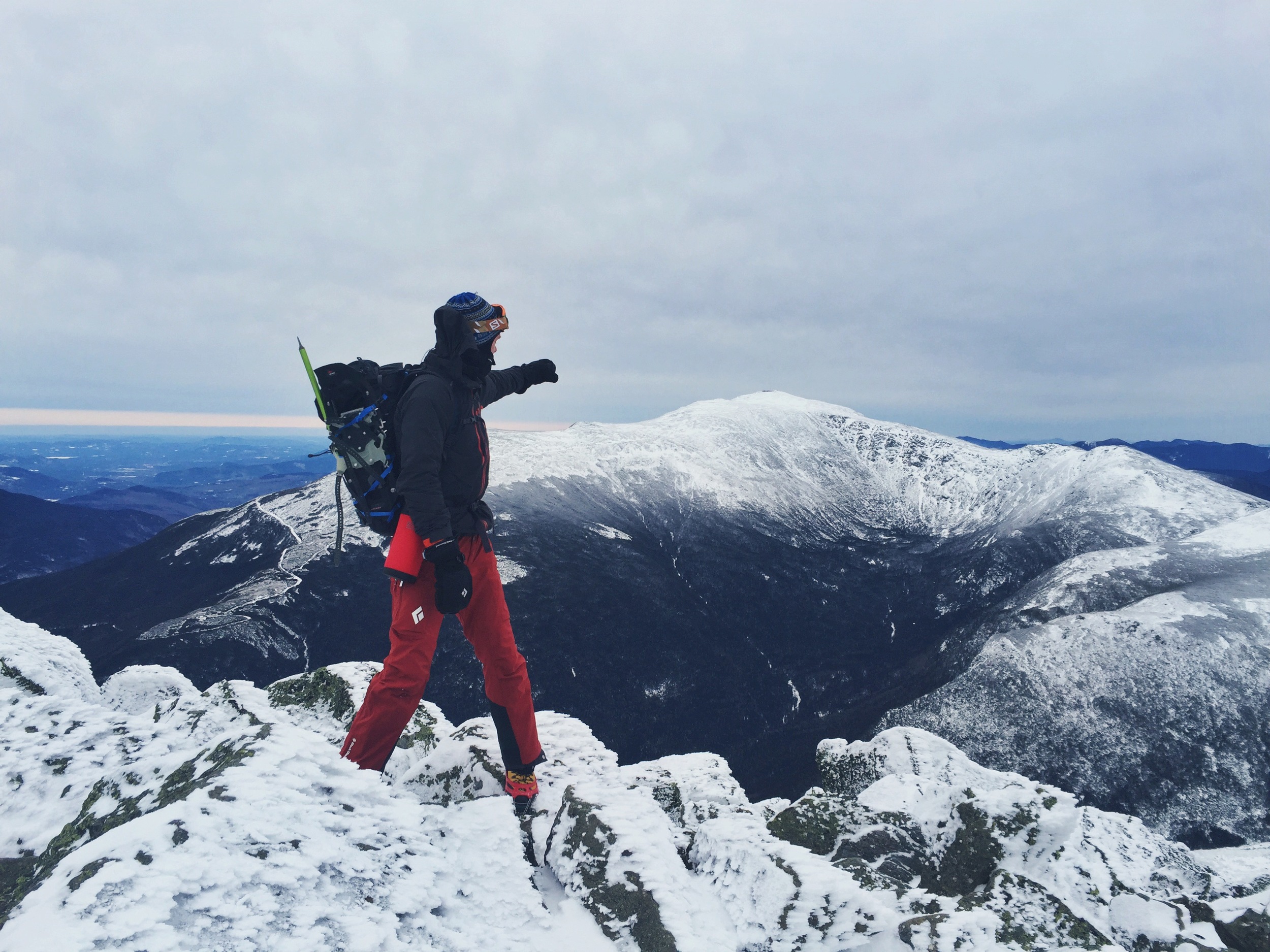
the Presidential Traverse is a route that crosses the entire Presidential Range of the White Mountains in New Hampshire. During the warm summer months, many hikers attempt the route as a multi-day trek. With the aid of the extended daylight hours, a strong few will tackle the route as a day hike. Only a handful of daring individuals will tackle the entire 17 mile traverse, in the midst of winter, in one single day.
“A winter traverse of the Presidential Range is the most coveted–and riskiest–mountaineering
feat in the Northeast. ”
THIS 17.37 MILE TREK...
boasts nearly 9,000 feet of elevation gain as it traverses the five highest peaks in the northeast. With 11 total miles above tree line, the route is predominately exposed. Those same 11 miles are the epicenter of the notoriously erratic high summit weather that the White's are famous for. The nickname "Death March" is a reflection of this terrible weather, which is the greatest obstacle for those attempting the traverse. The Presidential range, which sees wind speeds over 100 mph 1 out of every 4 winter days, has claimed countless lives. Mt. Washington alone has seen 150 deaths since 1849. Just last year a seemingly experienced mountaineer perished no more than five miles into the traverse when she was caught in an unexpected blizzard. It is an adventure that is not to be taken lightly or underestimated. Being prepared for anything and everything is the name of the game on the Presidentials.
[The Presidential range] sees wind speeds over 100 mph 1 out of every 4 winter days.
The Presidential Traverse crosses eight peaks, seven of which are named after U.S. Presidents;
1. Mount Madison 5,367 ft.
5th highest peak in NE, named after fourth President of the United States, James Madison
2. Mount Adams 5,774 ft.
2nd highest peak in NE, named after second President of the United States, John Adams
3. Mount Jefferson 5,712 ft.
3rd highest peak in NE, named after third President of the United States, Thomas Jefferson
4. Mount Washington 6,288 ft.
Highest peak in NE, named after first President of the United States, George Washington
5. Mount Monroe 5,372 ft.
4th highest peak in NE, named after fifth President of the United States, James Monroe
6. Mount Franklin 5,003 ft.
Named after famed American Benjamin Franklin, non-presidential
Due to the severe weather we were unable to focus heavily on taking photos (messing with cameras while battling 70 mph winds in -10° weather is not all its cracked up to be). Unlike our regular adventure postings, this article will stand more as a resource, a list of the 10 most important things you need to know to tackle the traverse yourself... you can do it!
7. Mount Eisenhower 4,780 ft.
12th highest peak in NE, named after 34th President of the United States, Dwight D. Eisenhower
8. Mount Pierce 4,310 ft.
Named after the only president from New Hampshire, 14th President of the United States, Franklin Pierce
NOTE: An extension of the true Presidential Traverse exists including two additional non-presidential peaks; Mount Jackson 4,052 ft. named after New Hampshire geologist Charles Thomas Jackson, and Mount Webster 3,911 ft. named after New Hampshire U.S. Senator Daniel Webster. See elevation profiles below.
NOTE: All mileage is approximate, our data is derived from Caltopo.com and measurements taken from U.S. Forestry Maps. Most sources list the mileage of the traverse as much greater. We have stuck with the mileage our research produced to make our information consistent.
10 THINGS YOU NEED-TO-KNOW TO COMPLETE
A SUCCESSFUL WINTER PRESIDENTIAL TRAVERSE DAY HIKE
01. PAY ATTENTION TO THE WEATHER!
If there is anything you should take away from the history of man in the White Mountains, it is that you don't want to get caught above tree line when the weather turns its ugly head. There is a weather observatory on the top of Mt. Washington. It has been recording the three converging weather systems since 1932 and it's Higher Summits Forecast page should be the first place you visit when planning a traverse. Any White Mountain hiker worth his salt will tell you that there is no predicting the weather in the mountains. The Observatory should function as a precursor to the real forecast, the one you see when you pop your head above tree line. It is key that you always be aware of the ever changing skies and know your quickest route back to safety.
02. EXPECT 45-50 MPH WINDS, BE PREPARED FOR 70+
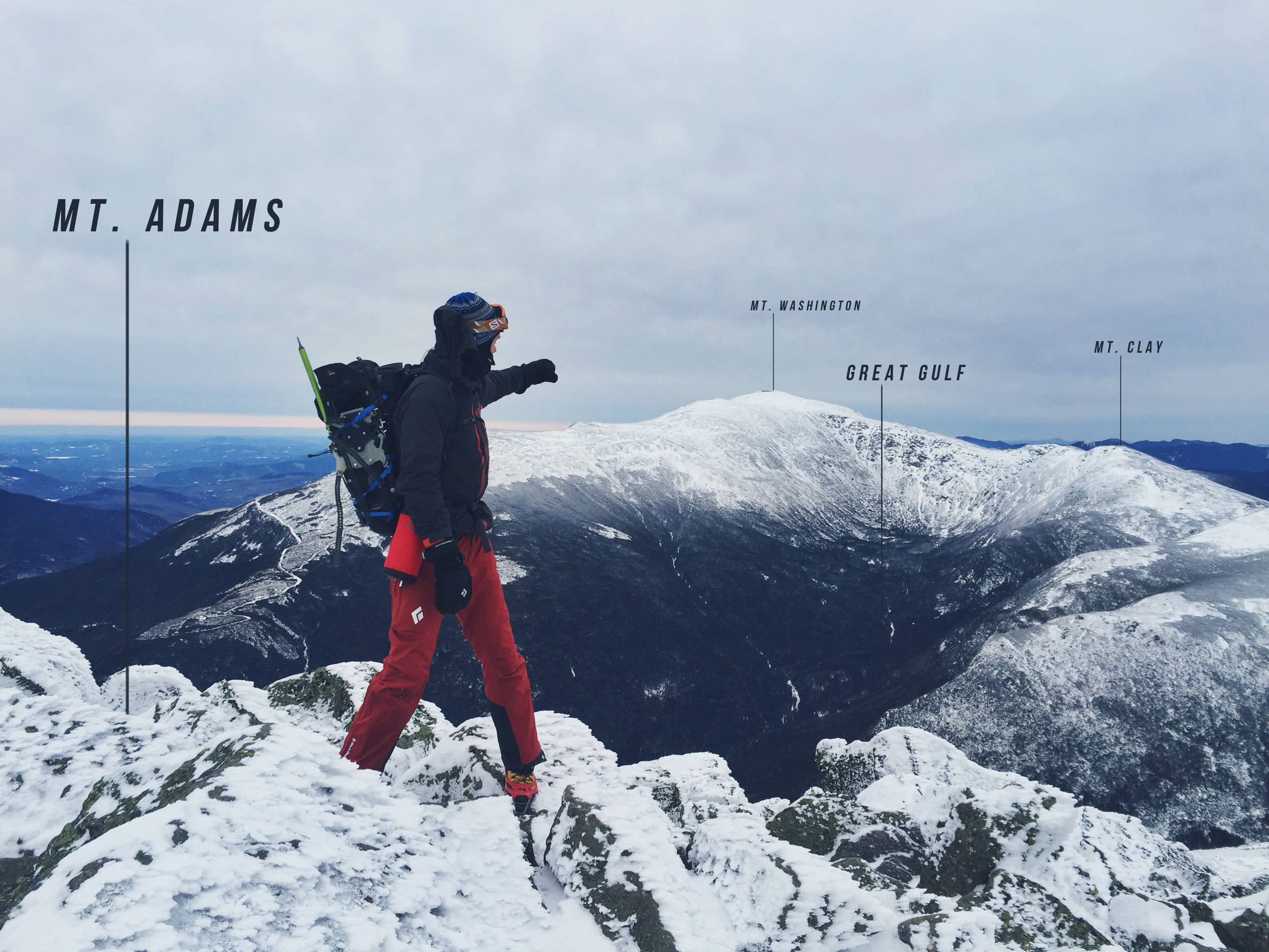
Upon reaching Mt. Madison, the first summit of the traverse, Teton broke out his wind gauge. The reading was already holding steady at 45 mph. The aggressive wind is something you should come prepared to deal with. There are multiple gullies and ravine ledges that you will cross, and these giant bowls will funnel and focus the wind into even stronger gust. It is important to focus on good footing throughout the trek, especially when along these ravines. Expect to see the worst winds around Mt. Clay and during your ascent on Mt. Washington - the Great Gulf Wilderness is superb at rallying the wind to its full force. We saw 70+ mph winds along this section.
03. SOME LOGISTICS ARE NEEDED
Unless you plan to yo-yo (turn around and do it all over again), know that upon completion you will be 12 miles, as the crow flies, from your starting point. To complete the trip you will need two vehicles in order to shuttle between beginning and end. To solve this dilemma, Teton invited his good friend, Chris Bennet, to join him on this adventure. Chris is a marathon runner, avid cycler, and established wedding photographer (www.cbennettphoto.com) whom Teton felt had what it takes to tackle the traverse.
It is important to start as early as possible. Get to the White Mountain National Forest the night before your hike day. Park and leave car one at the AMC Highland Center in Crawford Notch State Park (parking is free 24/7). Then drive north to the Appalachia Trailhead Parking lot in Randolph, NH. The earlier you arrive the better. By sleeping in your car at the trailhead the night before, you can eliminate unnecessary travel before your morning alpine start.
04. HEAD SOUTH
The most popular way to hike the traverse is by heading southbound. While some of the summits seem as though they would be easier if ascended from the opposite direction, the five highest and most strenuous peaks reside at the northern end of the range. By starting in the north you can knock out most of the elevation gain/loss early while you are fresh and coast through the less-elevated second half.
05. ESTIMATE A PACE AND ESTABLISH YOUR DAY'S PLAN
Establishing some sort of estimated pace allows you to easily visualize what the day should look like; where you will be when the sun comes up - where you will stop for lunch - will night hiking be necessary? We always recommend estimating a slower pace than expected when planning out the day ahead. By setting yourself up for a slower pace, you will only have time to gain. Any unexpected delays will have little effect on your overall pace. We set our baseline pace at 1 mph including breaks, lunch, etc. knowing that we would most likely move faster. With this pace in mind, we set our start time for 3 A.M.. This would put us on the summit of Mt. Madison at sunrise and give us a lunch break/rest on the top of Mt. Washington at noon.
06. PACK LIGHT, PACK SMART
a note about gear - Things to consider
- When preparing for a long distance day hike, it is important to balance weight and functionality. A full crampon would serve you better than MICROspikes® for traction in the alpine environment. But you must keep in mind that a crampon is nearly 2 lbs. per foot, while a set of MICROspikes® weighs less than 1 lb. in total. The extra weight from a crampon will certainly factor in overall exhaustion and slow your pace. Skip the crampons and let your snowshoes play a double role; giving you loft in deep snow and added traction if needed.
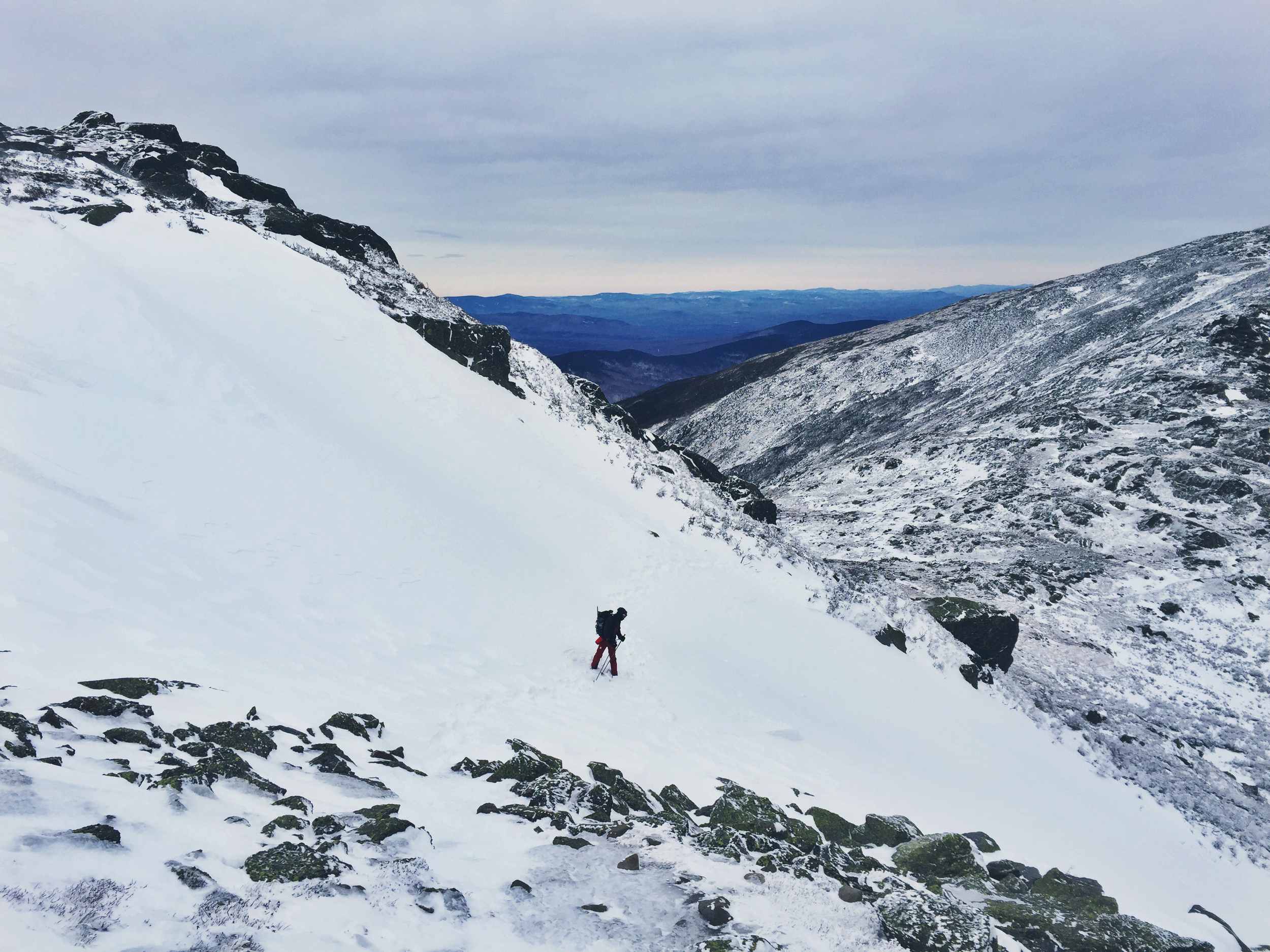
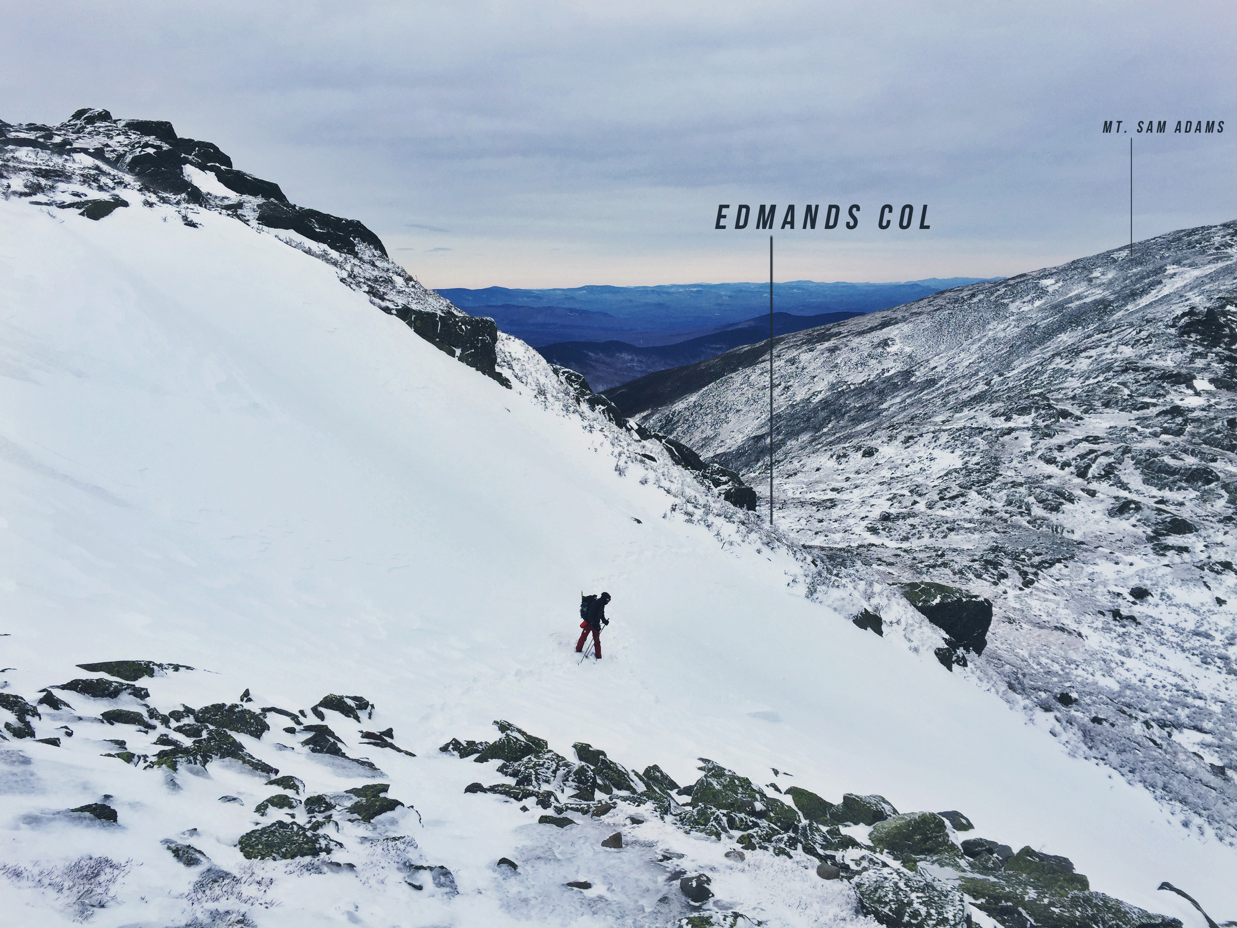
- While it is always smart to carry a piolet axe (pronounced: pee-oh-lay) when traveling above tree line, there is only a couple of places along the Presidential Traverse where one might truly utilize this tool. The first resides on the final slope heading south, out of Edmunds Col, where a large amount of snow builds up and precariously hangs on the steep slope. One slip or misstep while crossing this 50 yard section and you will find yourself barreling down the Jefferson Ravine (see photo below). The only other time we envisioned it being necessary was on the lower south side descent from Mt. Washington, where the wind had smoothed and iced over the terrain making the some-what-average slopes much more dangerous for slips and slides. Other than the fore-mentioned areas, the danger of falling with the need for self-arrest is minimal.
NOTE: changes in snowfall year-to-year will affect when and where a piolet may be needed.
- You may think that the extra emergency overnight gear is an unnecessary burden not worth the additional weight. It is important to remember that even the most experienced backcountry user can fall victim to unseen dangers or incidents. A smart and responsible backpacker always prepares for the worst case scenario. In this case, that can include an unforeseen overnight stay. Remember, it does not have to be comfortable, just survivable.
07. CONSIDER ADDITIONAL PRECAUTIONARY MEASURES
We are fortunate to have access to a SPOT™ device; this pocket sized GPS device sends out a tracking signal every 10 minutes. This signal allows people back home the option to follow and see our progress. The SPOT™ device also allows the user the ability to contact people when out of cell range including emergency services. While you may have luck on higher summits, one should expect to have little to no cell service anywhere in the Whites. It is handy to be able to let loved ones know that you are doing alright, alert them if you have hit a delay, or be able to request assistance if needed. Having a SPOT™ device is not a necessity, but it offers the people who care about you a bit of reassurance, and it betters your odds of being rescued if the worse should happen.
08. UNDERSTAND THE BURDEN OF RESCUE
There are multiple rescue groups operating in the White Mountains, many of which are volunteer based. It may take hours for rescuers to reach you in decent weather, and possibly days if the weather is at its worse. There is no sense risking the lives of many for one. Rescue is an intensive operation requiring multiple healthy bodies - it can take 12 or more to carry out just one litter. Rescues also tend to be extremely costly and the bill generally ends up in the hands of the rescued. To protect yourself from these sorts of incidents, the New Hampshire Fish and Game department offers hikers the option to purchase a Hike Safe Card. This card costs the user $25 and protects them from rescue costs and fines from the date of purchase through the new calendar year. It is a small cost to pay to cover yourself from unpredictable accidents that could cost you thousands. We recommend anyone who participates in lengthy or particularly dangerous outings, purchase a Hike Safe Card.
09. KNOW YOUR I.C.E. ROUTES
I.C.E. stands for In Case of Emergency. These are your bailout routes back to tree line and potential safety. Within our maps (available below) we have outlined 10 different options averaging about 2 miles apart. It is important to reassess yourself and the rest of your party every time you cross an I.C.E. route, making sure everyone is strong enough to continue onward. It is important to note that many of the routes outlined run to the west. While descending off the west side of the range will land you closer to the road leading to your parked cars, the majority of the trails lead to Jefferson Notch Road which is closed during the winter. Some additional planning, or an acceptance of a long road walk will be needed for a successful emergency descent.
10. PLAN TO TAKE ADVANTAGE OF PROVIDED SHELTER
The multiple Observatory buildings on Mt. Washington will offer you sufficient refuge from the elements. They are not open in the winter, but they do create a decent wind block. We took advantage of this and stopped for a quick trail lunch. After reassessing our gear and water levels, we consumed some calories and added another layer before being forced to keep moving as the bitter cold began to set in. NOTE: After breaking tree line on Mt. Madison there are only three solid structures along the traverse; Madison Spring Hut at 3.95 miles, Mt. Washington Observatory at 9.38 miles, and Lake of the Clouds Hut at 10.85 miles. All three of these buildings are closed throughout the winter months but will provide some sort of protection from the elements. You will return to the shelter of tree line after descending Mt. Eisenhower around the 13.43 mile mark.


The final push
If you make it past Mt. Washington - Congratulations! The hardest part is over. At this point, unless shelter is necessary, most I.C.E. routes will take you nearly as long as completing the journey (ignoring the ups and downs of course). Take a moments pause at the iced over Lake of the Clouds, grab a snack in the shelter of the hut and head for your last major peak, Mt. Monroe.
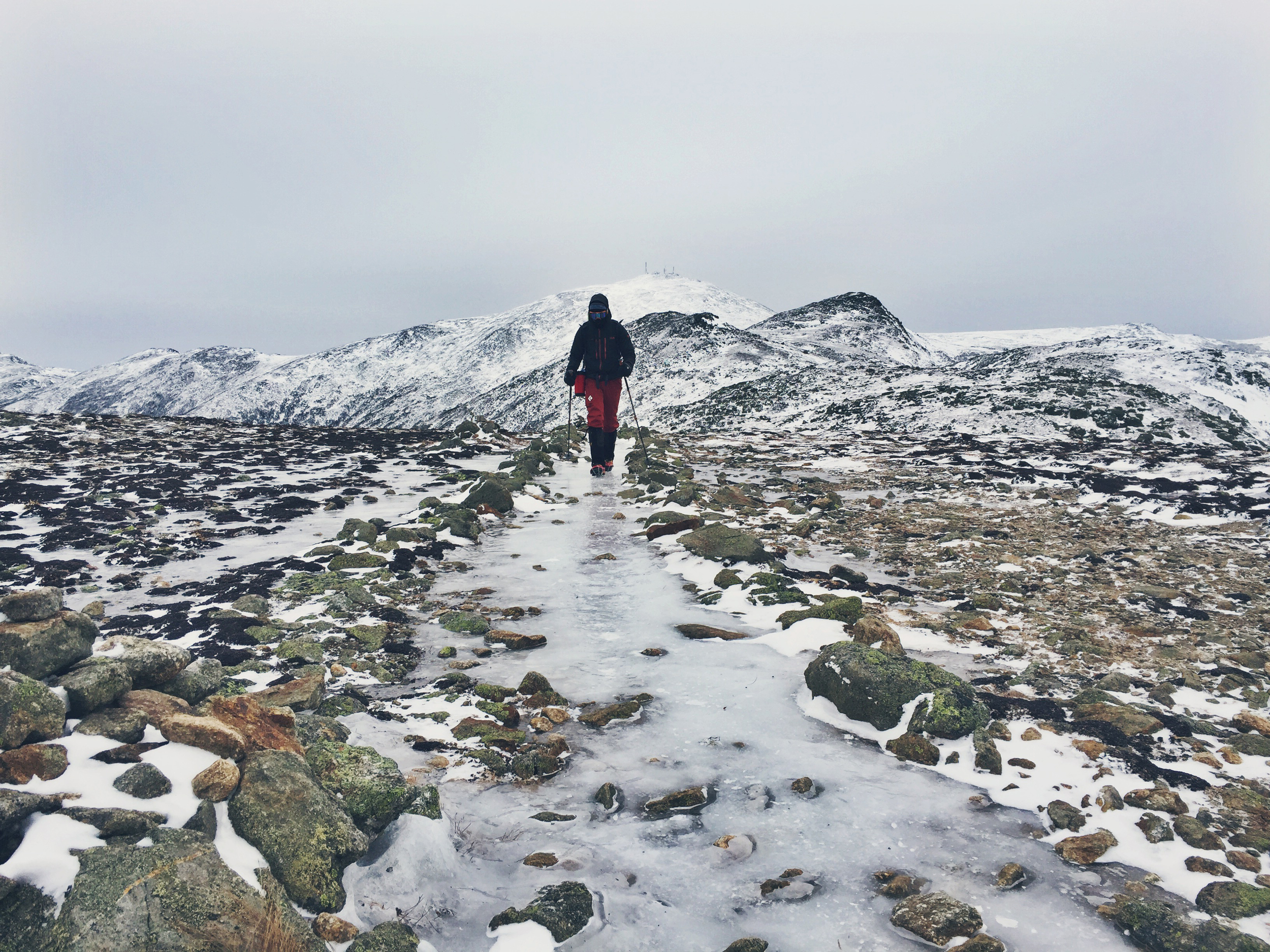
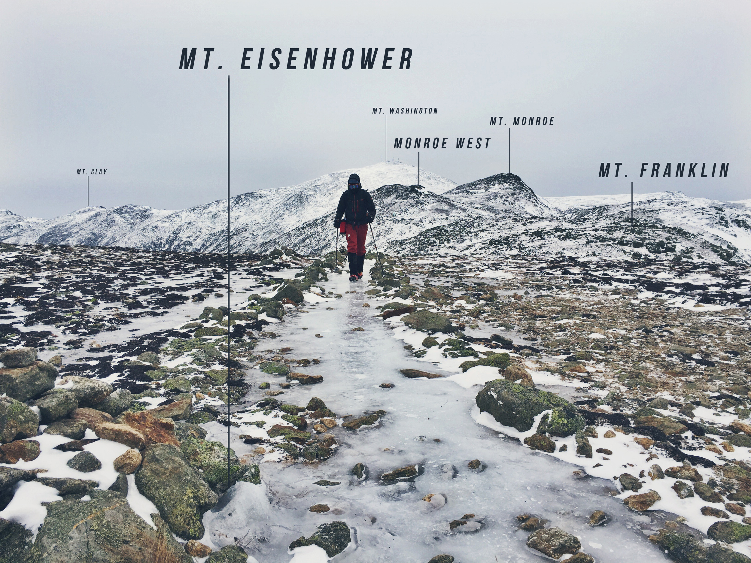
Mt. Monroe, oddly enough, was where we encountered the worst of the days winds. The ascent took us no time because the tailwind blew us right up the mountainside. Once on the ridge of Monroe it was a long and precarious step-by-step game. We both haunched down to make our profiles as small as possible as to not get blown off the peak. We would step to a rock, wait for the wind to settle slightly, quickly take another step to the next rock, wait. It was slow and tedious. Our guess was anywhere between 80-90 mph winds. Although it went without recording, it was strong enough to rip Tetons' GoPro pole mount clean off his trekking pole - lost forever to the windy abyss.
Once you cross the summit of Mt. Monroe, you are not done yet. After a slight downhill pitch, you climb right back up and over Monroe's secondary peak, Monroe West. A steady ridge line walk along the semi-unnoticeable Mt. Franklin is next. After crossing Mt. Franklin you will head downward, a definite morale buster as you watch the next peak, Mt. Eisenhower, grow ever taller in the distance. The large open bald summit of Eisenhower is the final push and it doesn't come easy. If you think you are done working after Monroe, you will be in for a surprise. Save some gas in the tank for this one.
FINISH STRONG
Shortly after summiting Mt. Eisenhower, you will descend back to the relative cover of tree line. A steady 1.54 mile hike will bring you to the final summit of the day, Mt. Pierce. Mt. Pierce has no summit marker or grand view. Hike up the ridge until you reach the highest point and call it a day. By this point Chris's feet were pretty torn up so we decided to head down the Crawford Path from Pierce rather than continue on to Mizpah Hut as outlined in our maps (view below). There is something magical about hiking along "the oldest continuously - used mountain trail" and we were happy to be on it in good condition. We were hours ahead of schedule - it was still light out - and for once the going was easy.
SUCCESS!
After 2.68 miles the Crawford Path ends (or starts rather) at the AMC Highland Center parking lot. We arrived at 4 PM exactly, crushing our prediction. We hiked from 3 AM to 4 PM, a total trip time of 13 hours, giving us a pace (including multiple rest and stops) of 1.34 mph.
UPDATE 02/28/16: The Whites claim another experienced hiker, body found frozen between Mt. Adams and Mt. Jefferson on the Presidential Range. View story here: Initial Report - More Information